Large language models struggle with spatially explicit tasks, achieving only 37% accuracy, but connecting them to structured geographic knowledge graphs through GraphRAG improves accuracy to 81% by generating precise database queries instead of relying on textual patterns.

Large language models (LLMs) like ChatGPT have become widely used tools, but they face significant challenges when handling geospatial information. Ask ChatGPT “What cities with more than 1 mio inhabitants in Europe are east of Berlin?” and you might get a confident answer that’s incorrect. This limitation affects applications ranging from urban planning to logistics.
A recent master’s thesis by Simon Groß from the University of Vienna presents a practical solution: Spatial GraphRAG, a system that improves how AI handles geographic knowledge.
The spatial challenge
Traditional LLMs work like well-informed researchers without access to maps. When processing spatially-explicit questions, they rely entirely on text patterns from their training data rather than actual spatial relationships. This approach has clear limitations.
Groß’s research demonstrates this problem with concrete numbers. Standard LLMs achieve a maximum F1 accuracy score of just 0.37 on spatially explicit tasks. For complex questions involving multiple spatial concepts, performance drops to 0.08, indicating substantial room for improvement.
GraphRAG: a structured approach
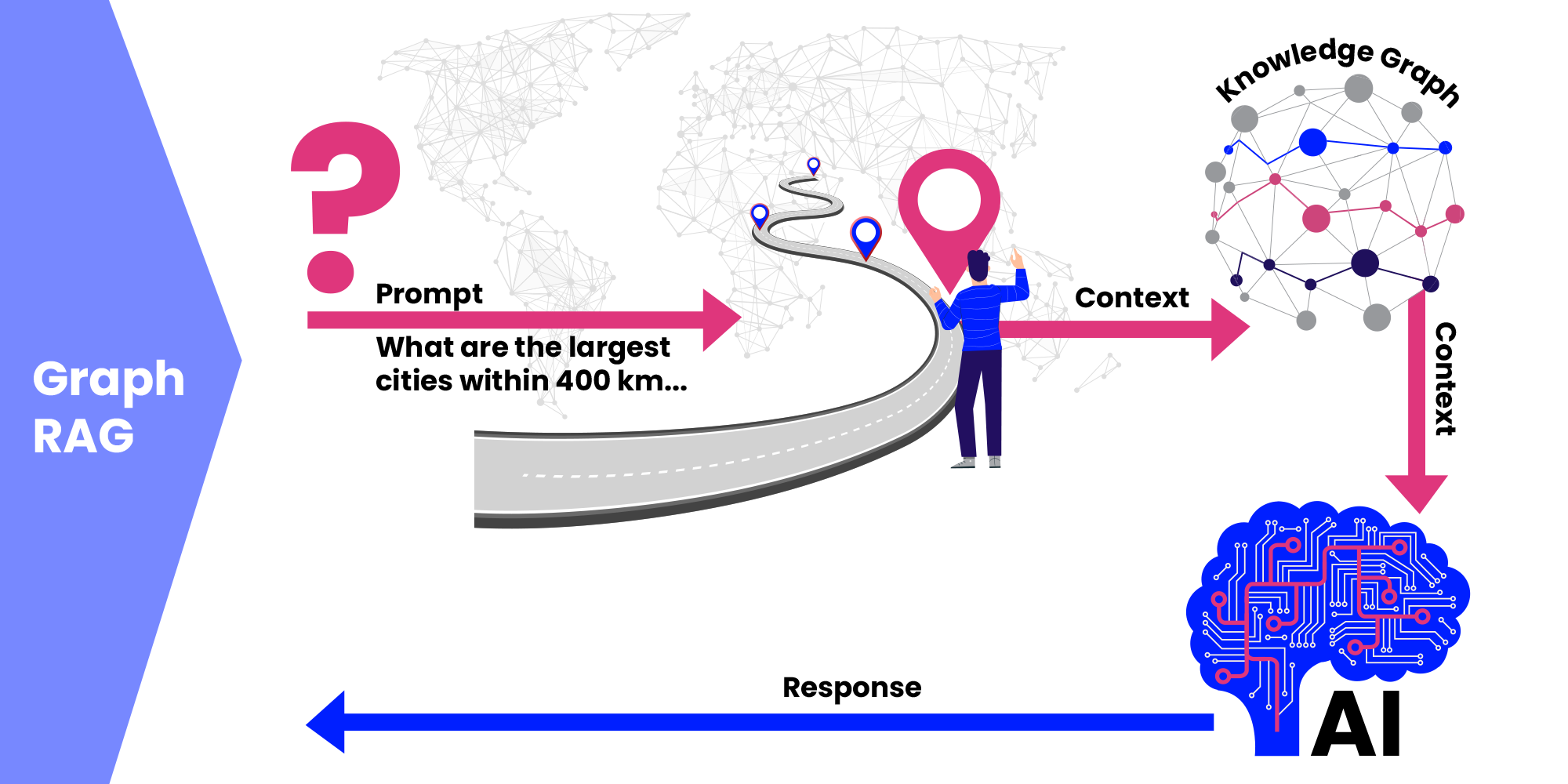
Graph-based Retrieval Augmented Generation (GraphRAG) takes a different approach. Instead of relying on textual patterns, it connects AI models directly to structured geographic knowledge graphs — databases that store spatial relationships with precision.
The process works as follows:
- Question processing
A user asks: “What are the largest cities within 400 km of the NUTS region RO41?” - Structure understanding
The system uses an ontology that explains how geographic data is organized within the knowledge graph. - Query generation
The LLM creates a GeoSPARQL query — a database language designed for spatial operations. - Data retrieval
The knowledge graph returns verified, structured data that forms the response.
This method connects AI systems to authoritative geographic databases containing European NUTS regions and Geonames cities, enabling more reliable spatial reasoning.

Measurable improvements
The results show clear performance gains:
Enhanced accuracy: GraphRAG achieved an F1 score of 0.81 — more than double the accuracy of traditional approaches. This represents a substantial improvement in reliability.
Complex query handling: While standard LLMs struggled with complex spatial questions, GraphRAG maintained consistent performance with F1 scores of 0.72. For simpler queries, accuracy exceeded 0.95.
Reduced misinformation: GraphRAG largely eliminates the fabrication of spatial information. When the system lacks sufficient data, it indicates uncertainty rather than providing incorrect answers.
Transparency: The approach allows users to examine the generated queries and retrieved data, making the reasoning process clear and verifiable. Knowledge base updates don’t require costly model retraining.
Practical applications
This research suggests several promising use cases:
- Urban planning systems that accurately analyze neighborhood relationships and accessibility
- Logistics platforms that properly account for geographic constraints
- Environmental monitoring tools that correctly correlate spatial and temporal data
- Emergency response systems that can identify affected areas and resource needs
- Spatial data science applications that rely on correct topological and spatial relationships
GraphRAG enables spatially-aware AI applications that require higher reliability than traditional approaches can provide.
Future directions
Groß’s work indicates that effective GeoAI development involves connecting AI systems to structured spatial knowledge rather than solely increasing model size or training data. This approach offers benefits in accuracy, explainability, and maintainability.
As AI and geographic information systems continue to develop, GraphRAG provides a practical framework for building AI systems with improved spatial understanding. The research demonstrates a viable path towards more reliable and transparent geospatial AI applications.
Discover more about the interplay of LLMs and GraphRAG!


